- CA BWGPL LHC-Map-OS11377
- Item
- 1860s
Part of Local History Collection
This drawing is a map of Bond Head in the 1860's based on historical data of the era.
2 results with digital objects Show results with digital objects
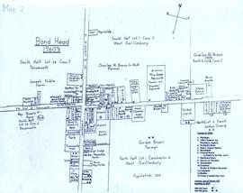
Part of Local History Collection
This drawing is a map of Bond Head in the 1860's based on historical data of the era.
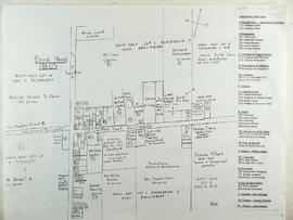
Part of Local History Collection
A map of Bond Head in the 1960's, including the main residents, active churches, and lot designations of the town.