Saint, Joe Transcript (#3)- On Family History
- CA BWGPL OH-Saint-Saint
- Part
- 1987-05-02
Part of Oral History Collection
Transcript of Joe Saint's family history talk.
Joe Saint
Saint, Joe Transcript (#3)- On Family History
Part of Oral History Collection
Transcript of Joe Saint's family history talk.
Joe Saint
Saint, Joe MP3 (#3) - On Family History
Part of Oral History Collection
This is a talk by Kenneth 'Joe' Saint at the West Gwillimbury Hall. He talks about the Saint Family History.
Joe Saint
Saint, Joe MP3 (#1) - On Moore Street
Part of Oral History Collection
An interview with Mr. Joe Saint describing what Moore Street used to look like in the 1920’s in regards to houses and churches.
George Jackson
Saint, Joe Transcript (#2) - On the Selby Cemetery
Part of Oral History Collection
Transcript of the interview with Joe Saint, by Miriam Swan.
Joe Saint
Saint, Joe MP3 (#2) - On the Selby Cemetery
Part of Oral History Collection
An interview with Mr. Joe Saint by Miriam Swan on the Selby Cemetery and various other cemeteries in Bradford and West Gwillimbury. Discussion includes the family history of the Selby Cemetery, and on Coulson's Hill cemetery,
Joe Saint
Part of Oral History Collection
Transcript of the interview with Miriam Swan, conducted by Joe Saint.
Joe Saint
Part of Oral History Collection
An interview with Miriam Swan by Joe Saint. They discuss the Jeff's Homestead, which is Miriam's home, and the Strafford's home.
Joe Saint
Part of George Jackson fonds
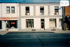
The structure located at 21 Holland St. West is part of what is known as the Evans Block. The building was raised and Len Saint added a cellar and a foundation. The work was done by Mac Campbell and his team of carpenters. T.W.W. Evans had the building constructed to house his law practice. The upstairs was also used for years by Dr. Ellis, a dentist. The upper floor even served as Bradford Library in the 1930s, run by Mrs. Day. At one time, the offices of Tupling Insurance were also located in this building. In 1957 a fire destroyed several buildings to the east, but this structure was spared. (1, 2)
George Jackson
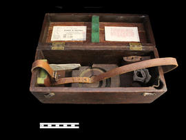
Storage Box for Professor Day's Level
Part of Local History Artifacts
Ae box for an instrument, a Keuffel & Esser level.
Part of a collection of Professor William H. Day's work equipment, donated by Joe Saint. Both the case and level were originally owned by Professor William H. Day, who was integral to the Holland Marsh Drainage Scheme's beginnings. The equipment was traded to Len Saint in the 1930s for a truck. The survey of the marsh determined the elevation of the muck soil and the bordering "highland" soils, providing the information the planners would need to determine the grades, estimate the materials to be moved and to determine the alignment of the canal.
Joe Saint
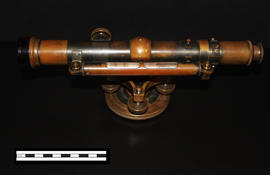
Part of Local History Artifacts
A Keuffel & Esser level that was used for activities such as surveying. It was originally owned by Professor William H. Day, who was integral to the Holland Marsh Drainage Scheme's beginnings. The survey of the marsh determined the elevation of the muck soil and the bordering "highland" soils, providing the information the planners would need to determine the grades, estimate the materials to be moved and to determine the alignment of the canal.
The drainage scheme report came out in 1924 and work began in the mid-1920s. The work involved intercepting part of the Holland River and the diversion of water around the perimeter of the area using drainage canals. Canal excavation materials were used to create dykes on the to-be reclaimed (marshland) side of the canals. The re-claimed land was used for farming and roads were constructed on top of the dykes to allow for transportation.
Joe Saint