- CA BWGPL WEG-Mar-OS9570
- Item
- 2000s
Part of WEGWHIST Collection
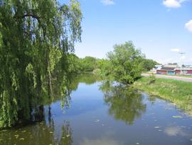
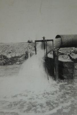
A view of the Marsh Canal looking north from the 5th line bridge.
13 results with digital objects Show results with digital objects
Part of WEGWHIST Collection
A view of the Marsh Canal looking north from the 5th line bridge.

Part of George Jackson fonds
"About 50 Holland Marsh farmers are suing the Townships of West Gwillimbury and King, claiming damage to crops in August because of flooding. The farmers served notice of their intentions through their lawyers last month, saying the two municipalities neglected to clean the Schomberg River, and that the pumps at a pumping station didn't work during the heavy rain of August 16. The petition signed by the farmers was sent to the councils by their lawyer Norman Borins of Toronto. It states that because of the failure of the pumphouse much of the land near or level with the river was covered with water. King Mayor Margaret Britnell said the township has no obligation to the farmers because the cleaning of the canal and pumping operations are under the jurisdiction of the Holland Marsh Drainage Commission. Council agreed to receive the letter and send it on to the commission. West Gwillimbury council has referred the matter to the township's insurance company, Frank Cowan Company Limited."
John Slykhuis
Part of WEGWHIST Collection
Part of Local History Artifacts
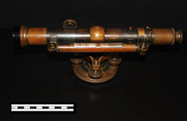
A Keuffel & Esser level that was used for activities such as surveying. It was originally owned by Professor William H. Day, who was integral to the Holland Marsh Drainage Scheme's beginnings. The survey of the marsh determined the elevation of the muck soil and the bordering "highland" soils, providing the information the planners would need to determine the grades, estimate the materials to be moved and to determine the alignment of the canal.
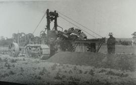
The drainage scheme report came out in 1924 and work began in the mid-1920s. The work involved intercepting part of the Holland River and the diversion of water around the perimeter of the area using drainage canals. Canal excavation materials were used to create dykes on the to-be reclaimed (marshland) side of the canals. The re-claimed land was used for farming and roads were constructed on top of the dykes to allow for transportation.
Joe Saint
Part of Local History Collection
Part of Local History Collection
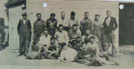
Professor W. H. Day, who initiated much of the work in the marsh operated the Kingwilbra Gardens beside Bridge Street. Tom Fuller Sr. was one of the workers on the marsh for the professor. Mr. Fuller recalled getting paid 17-cents an hour and then getting a rather substantial raise to 20 cents an hour. The work crew included Arthur Taylor, Jack Geddes (killed in action during the Second World War), Wilbert Mulliss, Bruno and John Carvalho, Frank Maurino, Herb Taylor, Homer and Howard Henbest, Gordon McKelvie, Bob Edney, Charles Hansford, Joe Sangdrige. In the photo, top left, A. Moffat, S. Foster, H. Taylor, Tom Fuller, A. Doan, J. Foster, W. Semenuk, B. Cudmore. Middle Row: N. Gilfin, A. West, M. Thompson, R. Smith. Bottom Row: J. Ellis, H. Ellis, Hunter, J. Sadur, M. Zlotkin.
Bradford West Gwillimbury Public Library
Part of Local History Collection
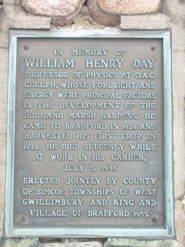
"In Memory of William Henry Day, Professor of Physics at O.A.C. Guelph, whose foresight and energy were principal factors in the development of the Holland Marsh Gardens. He came to Bradford in 1924 and harvested his first crop in 1928. He died suddenly while at work in his garden, July 5, 1938.
Erected jointly by county of Simcoe, Townships of West Gwillimbury and King and Village of Bradford 1955."
Amanda Gallagher
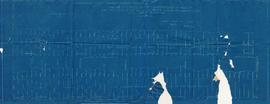
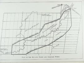
Profile of Dredge Cutting Blueprint
Part of John Harrison Fonds
Profile of dredge cuttings in the construction of part of the south part of the Holland River marsh drainage system in Village of Bradford. Blueprint, dated July 7, 1925.
John Harrison
Part of WEGWHIST Collection
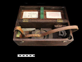
Storage Box for Professor Day's Level
Part of Local History Artifacts
Ae box for an instrument, a Keuffel & Esser level.
Part of a collection of Professor William H. Day's work equipment, donated by Joe Saint. Both the case and level were originally owned by Professor William H. Day, who was integral to the Holland Marsh Drainage Scheme's beginnings. The equipment was traded to Len Saint in the 1930s for a truck. The survey of the marsh determined the elevation of the muck soil and the bordering "highland" soils, providing the information the planners would need to determine the grades, estimate the materials to be moved and to determine the alignment of the canal.
Joe Saint