- CA BWGPL LHC-Dis-Hazel-2016-11-04-06
- Item
- 1979
Part of Local History Collection
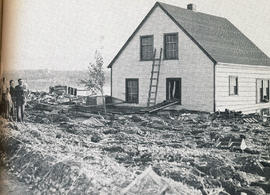
The dePeuter family standing next to their house, surrounded by debris. The debris came from the flood by Hurricane Hazel breaking the marsh's dykes.
Toronto Telegram
162 results with digital objects Show results with digital objects
Part of Local History Collection
The dePeuter family standing next to their house, surrounded by debris. The debris came from the flood by Hurricane Hazel breaking the marsh's dykes.
Toronto Telegram
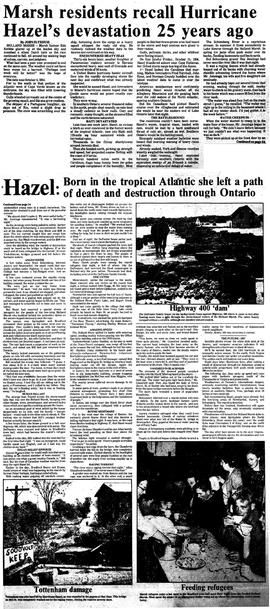
Marsh residents recall Hazel's devastation 25 years ago
Part of Local History Collection
Article on the 25th anniversary of Hurricane Hazel, with recollections from Marsh and Bradford residents
Bradford Witness

Part of George Jackson fonds
"About 50 Holland Marsh farmers are suing the Townships of West Gwillimbury and King, claiming damage to crops in August because of flooding. The farmers served notice of their intentions through their lawyers last month, saying the two municipalities neglected to clean the Schomberg River, and that the pumps at a pumping station didn't work during the heavy rain of August 16. The petition signed by the farmers was sent to the councils by their lawyer Norman Borins of Toronto. It states that because of the failure of the pumphouse much of the land near or level with the river was covered with water. King Mayor Margaret Britnell said the township has no obligation to the farmers because the cleaning of the canal and pumping operations are under the jurisdiction of the Holland Marsh Drainage Commission. Council agreed to receive the letter and send it on to the commission. West Gwillimbury council has referred the matter to the township's insurance company, Frank Cowan Company Limited."
John Slykhuis
Part of Local History Artifacts
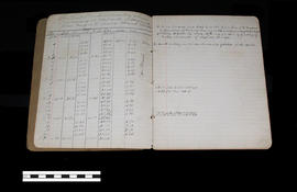
This notebook contains the levels taken and noted by Dave Sutherland for the Holland Marsh Reclamation Scheme. The second page (as seen in this image) states, "Holland Marsh reclamation scheme commencing at west side of Holland River going S.W. across marsh Feb 15/24."
Dave Sutherland
Part of Local History Artifacts
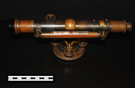
A Keuffel & Esser level that was used for activities such as surveying. It was originally owned by Professor William H. Day, who was integral to the Holland Marsh Drainage Scheme's beginnings. The survey of the marsh determined the elevation of the muck soil and the bordering "highland" soils, providing the information the planners would need to determine the grades, estimate the materials to be moved and to determine the alignment of the canal.
The drainage scheme report came out in 1924 and work began in the mid-1920s. The work involved intercepting part of the Holland River and the diversion of water around the perimeter of the area using drainage canals. Canal excavation materials were used to create dykes on the to-be reclaimed (marshland) side of the canals. The re-claimed land was used for farming and roads were constructed on top of the dykes to allow for transportation.
Joe Saint
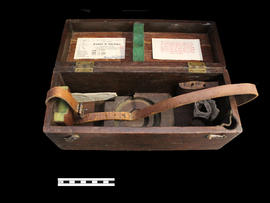
Storage Box for Professor Day's Level
Part of Local History Artifacts
Ae box for an instrument, a Keuffel & Esser level.
Part of a collection of Professor William H. Day's work equipment, donated by Joe Saint. Both the case and level were originally owned by Professor William H. Day, who was integral to the Holland Marsh Drainage Scheme's beginnings. The equipment was traded to Len Saint in the 1930s for a truck. The survey of the marsh determined the elevation of the muck soil and the bordering "highland" soils, providing the information the planners would need to determine the grades, estimate the materials to be moved and to determine the alignment of the canal.
Joe Saint
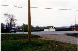
Part of Local History Collection
View of Bridge Street, looking south over the Holland Marsh and Canal Road.
Bradford West Gwillimbury Public Library
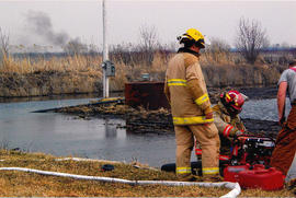
Part of Local History Collection
Photograph of firefighters tending to a bush fire on the edge of the Holland Marsh.
Bradford West Gwillimbury Public Library
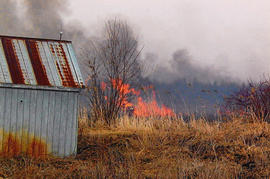
Part of Local History Collection
Photograph of firefighters tending to a bush fire on the edge of the Holland Marsh.
Bradford West Gwillimbury Public Library
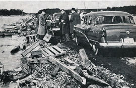
Part of Local History Collection
Debris from the marshland piling up along Highway 400. Photograph from Betty Kennedy's 'Hurricane Hazel,' found in the Local History Collection.
Toronto Telegram