This folder contains photographs of various historic buildings in Bradford and accompanying descriptions on each. The photographs are found in the Bill & Erica Marks Archive Room and were originally compiled by George Jackson and Joe Saint. The text accompanying each photograph was researched and written in 2015-2017 by Janice Hopkins, a long-time library volunteer. She utilized many library resources in her research which are noted at the bottom of each description. See below for information on each reference.
An interview with Mr. Joe Saint by Miriam Swan on the Selby Cemetery and various other cemeteries in Bradford and West Gwillimbury. Discussion includes the family history of the Selby Cemetery, and on Coulson's Hill cemetery,
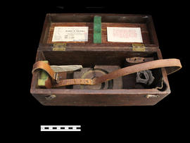
Ae box for an instrument, a Keuffel & Esser level.
Part of a collection of Professor William H. Day's work equipment, donated by Joe Saint. Both the case and level were originally owned by Professor William H. Day, who was integral to the Holland Marsh Drainage Scheme's beginnings. The equipment was traded to Len Saint in the 1930s for a truck. The survey of the marsh determined the elevation of the muck soil and the bordering "highland" soils, providing the information the planners would need to determine the grades, estimate the materials to be moved and to determine the alignment of the canal.
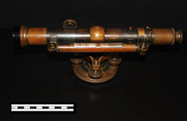
A Keuffel & Esser level that was used for activities such as surveying. It was originally owned by Professor William H. Day, who was integral to the Holland Marsh Drainage Scheme's beginnings. The survey of the marsh determined the elevation of the muck soil and the bordering "highland" soils, providing the information the planners would need to determine the grades, estimate the materials to be moved and to determine the alignment of the canal.
The drainage scheme report came out in 1924 and work began in the mid-1920s. The work involved intercepting part of the Holland River and the diversion of water around the perimeter of the area using drainage canals. Canal excavation materials were used to create dykes on the to-be reclaimed (marshland) side of the canals. The re-claimed land was used for farming and roads were constructed on top of the dykes to allow for transportation.