"The ties between "The Marsh" and the Netherlands seem to have been destined by fate's fickle finger. They stretch back to the earliest days of British settlement when in 1791 General Frederick Haldimand, Canada's Governor-in-Chief, assigned his Surveyor-General to do a survey of the Lake Simcoe area. Although a British army officer, the man was Dutch-born and by coincidence was named Samuel Johannes Holland." ...
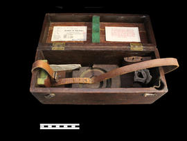
Ae box for an instrument, a Keuffel & Esser level.
Part of a collection of Professor William H. Day's work equipment, donated by Joe Saint. Both the case and level were originally owned by Professor William H. Day, who was integral to the Holland Marsh Drainage Scheme's beginnings. The equipment was traded to Len Saint in the 1930s for a truck. The survey of the marsh determined the elevation of the muck soil and the bordering "highland" soils, providing the information the planners would need to determine the grades, estimate the materials to be moved and to determine the alignment of the canal.
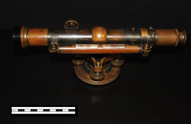
A Keuffel & Esser level that was used for activities such as surveying. It was originally owned by Professor William H. Day, who was integral to the Holland Marsh Drainage Scheme's beginnings. The survey of the marsh determined the elevation of the muck soil and the bordering "highland" soils, providing the information the planners would need to determine the grades, estimate the materials to be moved and to determine the alignment of the canal.
The drainage scheme report came out in 1924 and work began in the mid-1920s. The work involved intercepting part of the Holland River and the diversion of water around the perimeter of the area using drainage canals. Canal excavation materials were used to create dykes on the to-be reclaimed (marshland) side of the canals. The re-claimed land was used for farming and roads were constructed on top of the dykes to allow for transportation.