- CA BWGPL LHC-Map-OS11377
- Unidad documental simple
- 1860s
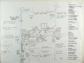
Parte deLocal History Collection
This drawing is a map of Bond Head in the 1860's based on historical data of the era.
3 resultados directamente relacionados Excluir términos relacionados
Parte deLocal History Collection
This drawing is a map of Bond Head in the 1860's based on historical data of the era.
Parte deWEGWHIST Collection
Contains information on the various hamlets around Bradford. Headings include: Amsterdam Ansnorsveldt Bond Head BWG and Surrounding Area Cookstown Coulson's Hill Deerhurst Dunkerron Fennel's Corners Fisher's Corners Gilford 1 of 2 Gilford 2 of 2 Holland Landing The Hollows Innisfil Lefroy Mackie's Corners Middleton 1 of 2 Middleton 2 of 2 Mount Pleasant Newton Robinson Pinkerton Scotch Settlement Steele's Corners Springdale Tecumseth Township Thompsonville (Beeton area) Hamlets - Other
Sin título
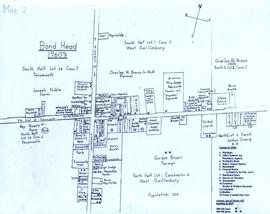
Parte deLocal History Collection
A map of Bond Head in the 1960's, including the main residents, active churches, and lot designations of the town.