- CA BWGPL LHC-Map-OS11377
- Unidad documental simple
- 1860s
Parte deLocal History Collection
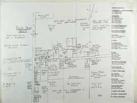
This drawing is a map of Bond Head in the 1860's based on historical data of the era.
3 resultados directamente relacionados Excluir términos relacionados
Parte deLocal History Collection
This drawing is a map of Bond Head in the 1860's based on historical data of the era.
Parte deLocal History Collection
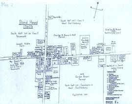
A map of Bond Head in the 1960's, including the main residents, active churches, and lot designations of the town.
Parte deWEGWHIST Collection
Contains information on the various hamlets around Bradford. Headings include: Amsterdam Ansnorsveldt Bond Head BWG and Surrounding Area Cookstown Coulson's Hill Deerhurst Dunkerron Fennel's Corners Fisher's Corners Gilford 1 of 2 Gilford 2 of 2 Holland Landing The Hollows Innisfil Lefroy Mackie's Corners Middleton 1 of 2 Middleton 2 of 2 Mount Pleasant Newton Robinson Pinkerton Scotch Settlement Steele's Corners Springdale Tecumseth Township Thompsonville (Beeton area) Hamlets - Other
Sin título