Map
Taxonomia
Código
Nota(s) de âmbito
Nota(s) da fonte
Mostrar nota(s)
Termos hierárquicos
Map
Termos equivalentes
Map
Termos associados
Map
- TR Drawing
12 Descrição arquivística resultados para Map
12 resultados diretamente relacionados Excluir termos específicos
Joseph Street (by Registered Plan 122A)
- CA BWGPL LHC-BUC-2023-12-01/24
- Item
- Unkown
Parte de Local History Collection
Copy of part of a map of Joseph Street as part of Registered Plan 122A. Captured in the copy is a couple of handwritten notes, including the name "John Bateman."
Sem título
- CA BWGPL WEG-Mar
- Pasta/Processo
- ? - 2018
Parte de WEGWHIST Collection
Contains information on the Holland Marsh in relation to Bradford's history. Headings include: Drainage 1 of 3 Drainage 2 of 3 Drainage 3 of 3 Hurricane Hazel Maps Marsh Disasters Marsh Hay Marsh History Photos Professor W.H. Day
- CA BWGPL LHC-Map-OS9690
- Item
- 1946
Parte de Local History Collection
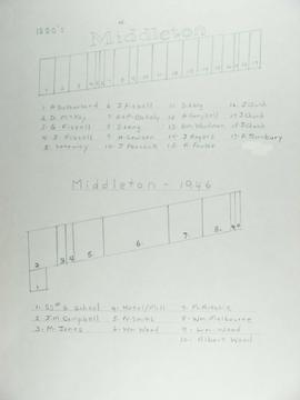
The top map shows Middleton as of the 1880's and the bottom map shows Middleton in 1946.
- CA BWGPL JS-Vol3-JSC-v3-1910
- Item
Parte de Joe Saint fonds
Contains maps of the Bradford West Gwillimbury & surrounding areas
Sem título
- CA BWGPL WEG-Ham
- Pasta/Processo
- ? - 2018
Parte de WEGWHIST Collection
Contains information on the various hamlets around Bradford. Headings include: Amsterdam Ansnorsveldt Bond Head BWG and Surrounding Area Cookstown Coulson's Hill Deerhurst Dunkerron Fennel's Corners Fisher's Corners Gilford 1 of 2 Gilford 2 of 2 Holland Landing The Hollows Innisfil Lefroy Mackie's Corners Middleton 1 of 2 Middleton 2 of 2 Mount Pleasant Newton Robinson Pinkerton Scotch Settlement Steele's Corners Springdale Tecumseth Township Thompsonville (Beeton area) Hamlets - Other
Sem título
- CA BWGPL LHC-Event-Carr-2018-11-09-05
- Item
- 2000-09-02
Parte de Local History Collection
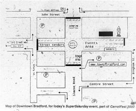
Map of how Downtown Bradford would be set-up for Carrotfest, printed in the Bradford West Gwillimbury Times.
Sem título
- CA BWGPL WEG-EaSet
- Pasta/Processo
- ? - 2018
Parte de WEGWHIST Collection
Contains items relating to the Early Settlement of Bradford and West Gwillimbury. Headings include:
Early Settlers General 1 of 3
Early Settlers General 2 of 3
Early Settlers General 3 of 3
Early Maps of Township
*East Gwillimbury & King Township
Sem título
- CA BWGPL LHC-Map-Index
- Item
- 2018
Parte de Local History Collection
Index to the Map & Plan Collection held in the Bill & Erica Marks Archive Room.
Sem título
- CA BWGPL LHC-Map-2019-01-08-02
- Item
- 1878
Parte de Local History Collection
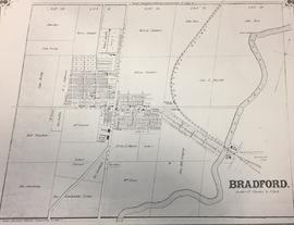
Map of what Bradford looked like in approx. 1878.
Sem título
Resultados 1 a 10 de 12